Home
Knowledge Hub/FAQ
Frequently Asked Questions
Curious to find out more? Dig into our FAQs below.
Introduction
A drone is a robot that may be terrestrial, marine, submarine, spatial or aerial. In practice, the term relates to aerial drones, i.e. an "aircraft without a person on board", or "Unmanned/uncrewed Aircraft System" or simply “UAS”.
There is a huge variety of drones in size, shape and mass, ranging from nano-drones to large, high altitudes unmanned planes.
A drone is actually more than an aircraft, it is a global system consisting of the following primary elements:
- The aircraft, also referred to as the platform, the unmanned aircraft (UA), or the unmanned air vehicle (UAV);
- The ground station enabling the remote pilot to remotely control the aircraft;
- The GPS system (satellite-based Global Positioning System) for aircraft real-time geo-localisation;
- The communication uplink to transmit the remote pilot’s commands to the aircraft;
- The communication downlink to transmit the video feed and the aircraft data back to the ground station.
Classification of drones
By definition constraints induced by having a person onboard do not apply to drones. As a result, designers have developed novel architectures to meet the specific needs of each mission.
In general, drones are classified in 3 main categories:
- Fixed wings
- Rotating wings, especially multi-rotors
- Convertible or hybrid or VTOLs (“vertical take-off and landing”)
FIXED WINGS
Fixed wings are designed as airplanes
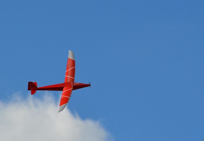
Photo of AVEM Aeromapper, The Drone Office
Drones designed like traditional aircrafts are generally composed of a fixed wing, a fuselage, a drift and a tail. This type of drone offers greater endurance, they can fly longer and over longer distances. They are well suited for inspection missions over railway lines, pipelines and maritime borders. On the other hand, they lack manoeuvrability compared to multi-rotors. Turning may require a relatively wide radius of action, taking-off may require launching by hand or catapult, and landing may require a certain landing area.
Fixed wings are designed as « flying wings »
Flying wings are self-stabilised by virtue of their shape. Their manoeuvrability allows to follow a pre-determined flight plan, even in case of wind gusts. They are well suited for use cases such as agriculture, mines and quarries inspection and monitoring.
Rotary Wings, Multi-rotors
Rotary multi-rotors account for most of the recreational drone market and professional drone market.
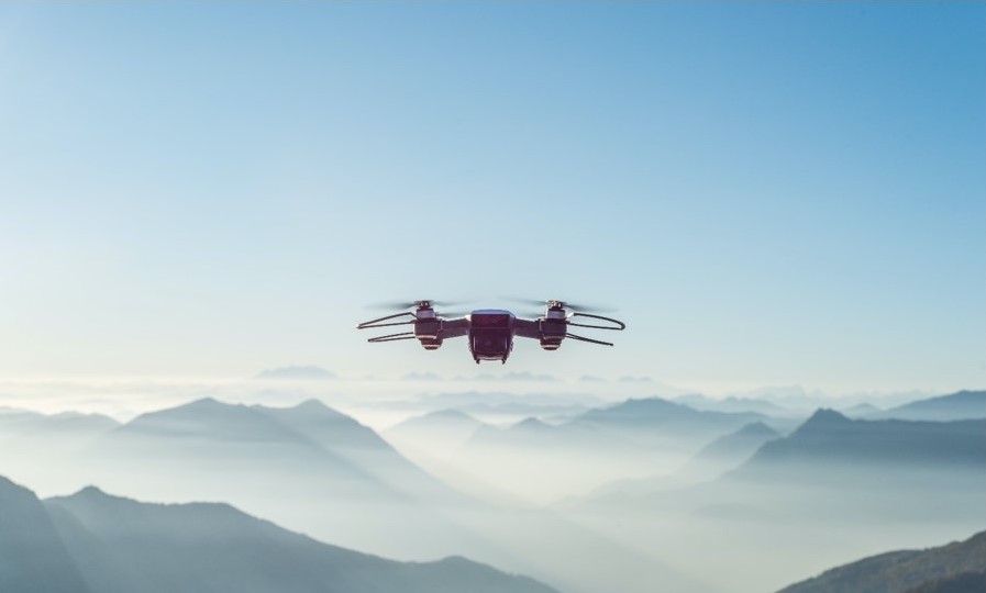
Photo by Alessio Soggetti on Unsplash.
The lift capability of a multi-rotor drone is produced by the rotating rotors and not by wings exerting a pressure on air like airplanes do. Instead, a multi-rotor stabilises and moves thanks to the speed modulation of its multiple rotors. A drone with 4 rotors is called a quadcopter or quad, with 6 rotors an hexacopter, with 8 rotors an octocopter.
The higher the number of rotors, the higher the power, the higher the payload and/or endurance capacity. In addition, rotor redundancy improves drone safety: with 6 rotors and more, in the event of one motor failure, the other engines can compensate and better support an emergency landing.
Limited autonomy induced by LiPo batteries
Multi-rotors operate with an electric propulsion system powered by lithium polymer or LiPo batteries, with high energy density and fast discharge. Their autonomy or flight time is therefore limited. Order of magnitude is 10 minutes for toys and 30 minutes for higher end leisure and professional drones. This constraint is acceptable in a visual line of sight operation, where a 30-minute flight is enough to collect the data and images required by the mission. However, it is challenging in the context of longer endurance or beyond visual line of sight flights.
Rotary wings designed as “helicopters”
Helicopters account for a marginal share of the current drone market. However, projects are under way for the transport of passengers, and some designs are inspired by helicopters.
Hybrids or « VTOL »
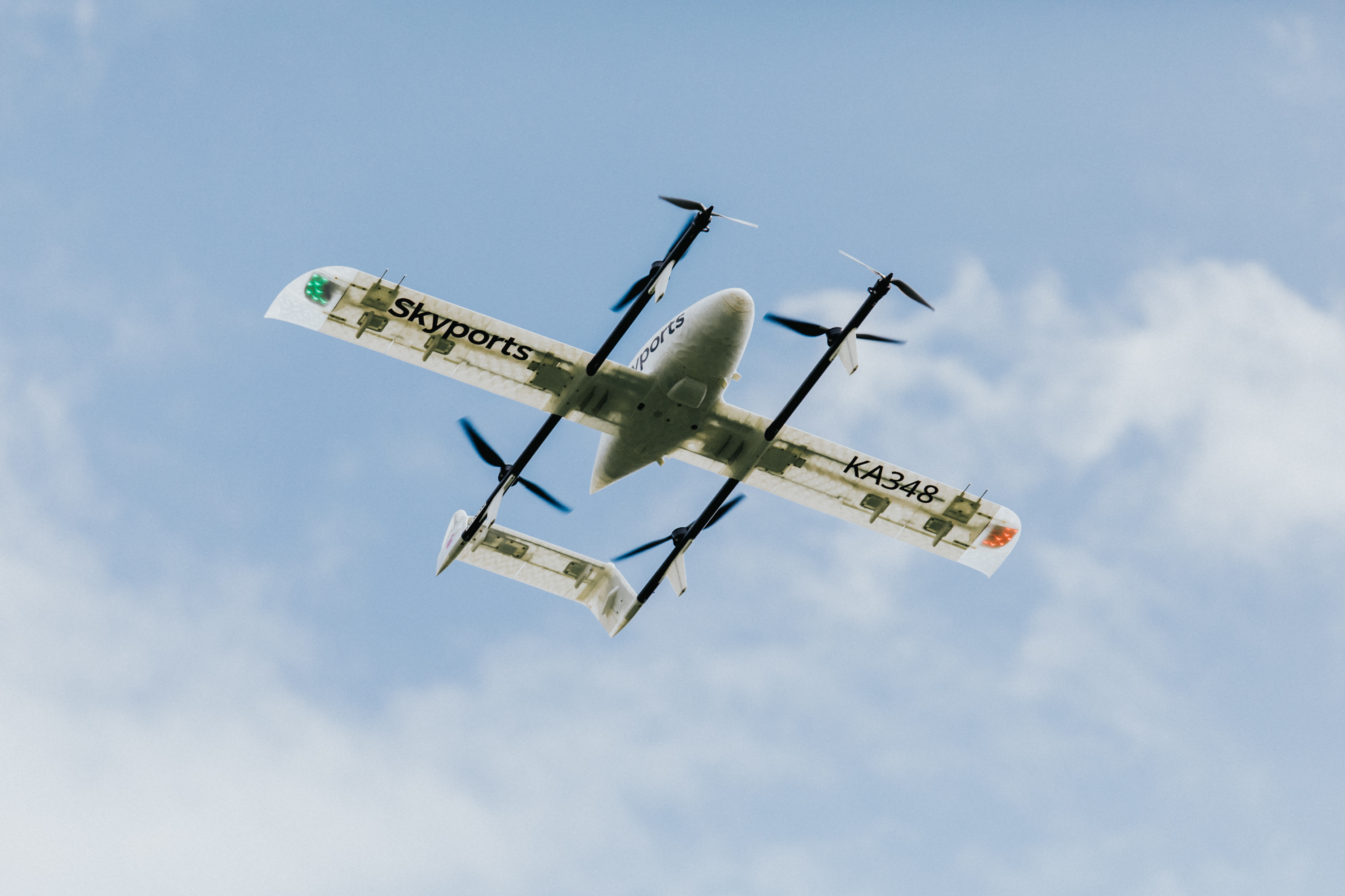
Photo by Gabriel Reynolds, Skyports
Fixed-wing aircraft such as airplanes or gliders take advantage of the lift, the force created by the wings and pushing them upwards. This allows them to fly over greater distances compared to multi-rotors. However, fixed wings must fly within their flight critical parameters in terms of angle of incidence and minimum speed, otherwise they may lose their lift, stall and fall. As a result, changes in trajectory are performed in ample movements, and minimum areas are required for take-off and landing. This can prove complicated in a city environment, albeit an option is to land on large flat roofs.
Multi-rotors on the other hand offer greater manoeuvrability, they can perform stationary flights, and can effortlessly turn at 90, 180 or 360 degrees. However, since they do not glide, LiPo batteries limit their autonomy to about 30-minute flights for high-end leisure and professional drones.
Convertible, or hybrid, or VTOL for "vertical take-off and landing" drones strive to take advantage of the benefits and to compensate for the limits of both designs. These are aircraft that combine multi-rotors used in the landing and take-off phases and a fixed wing during flight.
ICAO, the United Nations Civil Aviation agency
The International Civil Aviation Organization (ICAO) is the specialised agency of the United Nations in air transport created at the 1944 Chicago Convention. It changes the principles and techniques of international air navigation and fosters the planning and development of international air transport to ensure safe and orderly growth. The ICAO standards do not supersede the primacy of national regulatory requirements: it is always the local, national regulations which are enforced in, and by, sovereign states. However, in practice, sovereign states implement ICAO standards in their national regulations.
National Civil Aviation agencies, such as the UK Civil Aviation Authority
In the United Kingdom, the Civil Aviation Authority (CAA) is the statutory corporation which oversees and regulates all aspects of civil aviation.
A new regulation package came into force in the UK on 31 December 2020. It defines 3 categories called Open / Specific / Certified depending on the level of operational risk.
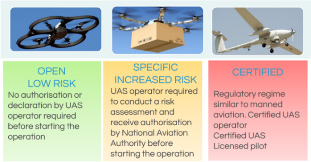
Image: EASA, CAA
«Open » category
Operations in the Open category present the lowest risk. They are not subject to any prior authorisation, nor to an operational declaration by the Unmanned/uncrewed Aircraft System (UAS) operator before the operation takes place.
The Open Category’s key restrictions are:
- Maximum mass of 25kg
- Flight in Visual line of sight only “VLOS”
- Maximum height of 120m 400ft
- No dangerous goods carried, no dropping of material.
« Specific » category
The simplest description of a Specific Category operation is that it is a UAS operation ‘that cannot be done within the Open Category but is not complicated enough for the Certified Category’. These operations will require prior authorisation from the competent authorities, i.e. the Civil Aviation Authority (CAA) based on a thorough risk assessment and mitigation plan.
2 options can be implemented to apply for an Operational Authorisation with the CAA:
- application based on a risk assessment completed by the UAS operator and like an Operating Safety Case
- application based on a Pre-Defined Risk Assessments (PDRA). The CAA will carry out the risk assessment themselves and will publish, as an acceptable means of compliance to the drone regulation, a standard set of requirements that the UAS operator must provide in its application for Operational authorisation – like a detailed recipe that must be followed exactly - . In the UK, the CAA refers to UKPDRA01 as part of CAP722 to convert the existing standard permission for Commercial UAS Operation into the new regulation.
« Certified » category
Considering the level of risk of damage to property and/or people, safety requirements are like manned aviation. Operations in the certified category should, as a principle, be subject to rules on certification of the aircraft, certification of the operator, licensing. The following operations will be classified as “certified”:
- flying over assemblies of people
- transporting people
- carrying dangerous goods that may result in high risk for third parties in case of accident.
Category of medical drone delivery
The CAELUS flying demonstrations should fit in the remit of the Specific Category. They require specific Operational Authorisations delivered by the Civil Aviation Authority (CAA), following their review and approval of the Operating Safety Case identifying and mitigating all the risks of the contemplated operation.
VLOS
Flying within “Visual Line of Sight” VLOS is a major pre-requisite of the Open Category in the UAS regulation. It means that the remote pilot maintains visual contact with the UAS at all times and can perform the “Detect and Avoid” function, “DAA”. The remote pilot detects any other airspace user and avoids an air-based collision.
EVLOS
The distance may be extended, typically to a few kilometres, when the remote pilot works with a team of observers who scan the sky and stay in constant communication. This is referred to as “Extended VLOS”.
BVLOS
Flying BVLOS or "Beyond Visual Line of Sight" means that the remote pilot is not in constant visual contact with the drone, because it is flying long distance, or it is simply behind trees or a building.
Detect and Avoid DAA
The “Detect and Avoid other airspace users” function will be performed by a set of technological advances and systems, such as electronic conspicuity where airspace users in a specific area are equipped with devices transmitting their positions in real-time, creating a real-time map of airspace users; Unmanned Traffic Management UTM systems that would manage the traffic and perform de-confliction of flightpaths, like a fully automated air traffic control.
What is autonomy?
The automotive industry is a major contributor to thought leadership when it comes to autonomous vehicles. The Society of Automotive Engineers (SAE), defines 5 degrees of automation (not autonomy).
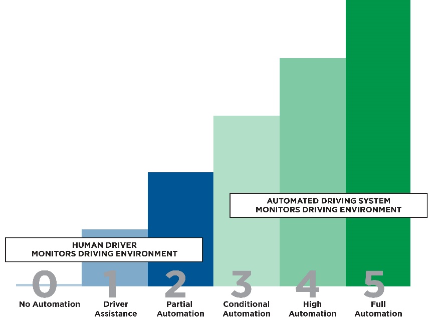
Society of automotive engineers , standard J3016 |
CAP722 by the Civil Aviation Authority (CAA) guidance on "Autonomy and Automation"
The dictionary definition of autonomy is “freedom from external control or influence”.
At this point in time all Unmanned/uncrewed Aircraft Systems (UAS) are required to perform deterministically. This means that their response to any set of inputs must be the result of a pre-designed data evaluation output activation process.
"As a result, there are currently no UAS related systems that meet the definition of autonomous."
The drone or UAS operator is legally accountable for the safe management of the aircraft and must decide the necessary level of preparation, training, planning and oversight for the conditions and circumstances of flights. This includes flights they carry out themselves or that are carried out by anyone else using the operator’s aircraft.
The remote pilot is responsible for carrying out the flight safely within the management framework set out by the operator. Operators must make sure they have effective management oversight for all flights using their aircraft.
Also, the law sets out some requirements for manned aviation that also apply to unmanned aircraft, with regards to key safety principles:
- endangering safety of an aircraft: “A person must not recklessly or negligently act in a manner likely to endanger an aircraft, or any person in an aircraft.”
- endangering safety of any person or property: “A person must not recklessly or negligently cause or permit an aircraft to endanger any person or property.”
We may have used acronyms, or you may read unfamiliar terms in news articles. Here are some key terms and definitions, primarily sourced from the UK key regulatory document called CAP722D. To access the complete document on the CAA website, click here.
BVLOS: Beyond Visual Line of Sight
CAA: Civil Aviation Authority, the UK regulator
DAA: Detect and Avoid
RPAS: Remotely Piloted Aircraft System
UAS: Unmanned/uncrewed Aircraft System(s)
RPAS, UAS and drones essentially refer to the same thing, an uncrewed aircraft and the various equipments needed to operate it.
What is an aircraft? Any machine that can derive support in the atmosphere from the reactions of the air other than the reactions of the air against the Earth’s surface.
What is Safety? Safety is the state in which the risk of harm to persons or property is reduced to, and maintained at or below, an acceptable level through a continuing process of hazard identification and risk management.
What is a Remote Pilot? A natural person responsible for safely conducting the flight of an unmanned aircraft by operating its flight controls, either manually or, when the unmanned aircraft flies automatically, by monitoring its course and remaining able to intervene and change the course at any time.
What is a Remotely Piloted Aircraft System (RPAS)? A remotely piloted aircraft, its associated remote pilot station(s), the required command and control links and any other components as specified in the type design. Note: Remote pilot station is a legacy term and has been replaced by command unit. Note: RPAS is a subset of Unmanned Aircraft System.
What is BVLOS? A type of operation that is not conducted in VLOS Visual Line of Sight.
What is a Visual Line of Sight (VLOS) Operation? A type of UAS operation in which the remote pilot is able to maintain continuous unaided visual contact with the unmanned aircraft, allowing the remote pilot to control the flight path of the unmanned aircraft in relation to other aircraft, people and obstacles for the purpose of avoiding collisions.
What is a Command and Control (C2) Link? The data link between the remotely piloted aircraft and the Remote Pilot Station for the purposes of managing the flight.
Do you need another term explained? Please email us at hello@projectcaelus.uk
In public surveys on the use of drones, security often came up high on the list of concerns by the public. “What if… something happens? How do you deal with problems such as misuse?”
In this section, we will try and answer security questions raised - to the best of our knowledge. You should feel free to ask further questions by adding a comment, or by emailing us at: hello@projectcaelus.uk.
First, what do we mean by Security?
If we refer back to conventional aviation and to Annex 17 “Security” of the Convention on International Civil Aviation by ICAO, the International Civil Aviation Organization, Security is defined as:
“Safeguarding civil aviation against acts of unlawful interference. This objective is achieved by a combination of measures and human and material resources.” "Acts of unlawful interference are acts, or attempted acts, such as to jeopardize the safety of civil aviation and air transport."
In other words, a security incident means that a person, or an organisation, takes actions that are against the law and result in the drone or its cargo injuring other people.
We often consider that a security incident implies malicious intent, but it is not always the case: people are not always aware of the law, and the “unlawful act” can be unintentional.
Also security is different from safety. Safety incidents refer to incidents that may lead to injury or loss and that are due to the aircraft, its systems and its operations themselves. For example: an engine failure, a technical failure, sudden extreme weather conditions like a storm, or human factors issues like the remote pilot having a heart attack.
Mandatory registration is applicable to all drones in the UK.
The only exception is for drones lighter than 250 grams that are either toys or do not have a camera. For example, the DJI Mini weighs less than 250g (249g) but has a camera, therefore you must register.
That way, each drone actually has an identifiable Operator ID label and a verifiable pilot behind it in the first place.
It is against the law to fly a drone without having the required IDs. People can be fined for breaking the law when flying. In the most serious cases, they could be sent to prison.
For more information, check the Civil Aviation Authority web pages on The Drone Code. Check the documents shared in the library below.
Tracking technologies forming the first steps of “Unified or Unmanned Traffic Management UTM” will give a real-time map of which drones are flying in a particular area. These solutions will provide the assurance whether the drones operating nearby are legal and safe.
The drone would provide real-time information during the flight so that it can be tracked and identified – like a “Find My” app on a smartphone. Anonymized ID information would be accessible to the public. More detailed information would be transmitted to the Traffic Management system to create that real-time flying map and ensure the safety and efficiency of flying operations.
One way of performing that real-time tracking is called "Remote ID", or “digital license plate” for drones. Tracking technologies like remote ID serve several purposes: privacy, security, facilitating law enforcement, and it is a building block for advanced operations. More importantly, tracking technologies help increase public trust in drone operations by providing assurances that the drones operating nearby are legal and safe.
Tracking technologies like remote ID are on their way both in the USA and in Europe. However, it is not fully implemented yet, and we will share return of experience in the course of the project..
For more information, check the documents shared in the library.
James Dunthorne, CEO of Neuron Innovations, explains to us in simple terms how available technologies provide surveillance and tracking functionalities. Tracking means being able to see where things are in the sky, in 3D space and in time, whether that's a drone or a conventional aircraft. There are a number of tracking technologies today in crewed aviation, ADS-B being one of the most used ones. Those technologies have vulnerabilities, like fake data or spoofing. But there are ways to address those vulnerabilities, such as multi-lateration and authentication. That tracking information can be used for a variety of purposes, including planning, security and safety.
Neuron Innovations is a UK-based blockchain start-up founded in 2019. Its flagship product provides drone systems with connectivity to ground based, aircraft tracking sensors, so that they can build up a picture of all air traffic movements, and safely manage conflicts between drones and aircraft. Neuron Innovations uses blockchain technology in order to provide an audit trail of all data transactions, and to provide incentive payments to users.
www.neuron.world
Watch our discussion with James Dunthorne, CEO of Neuron Innovations, on tracking technologies
Neuron Innovations technology provides a trust layer of future mobility, particularly ensuring the safe separation of aircraft. www.neuron.world
Summary
Most drones use GNSS/GPS, meaning Global Navigation Satellite System, to determine their precise location, navigate, and follow their automated flight paths.
Interference in satellite signals from other electronic devices is becoming a growing issue, not only for drones, and not only due to malicious intent!
A degraded GNSS/GPS signal, or the loss of signal during a flight, can start for many reasons, mainly interferences from the environment. It is a known vulnerability and it is therefore mitigated and managed. Mitigation and safety measures may include the redundancy of sources of positioning data with inertial sensors onboard, automatic fail-safe modes such as Return to Home, anti-jamming equipment. Some drones on the market are specifically conceived to navigate in a GNSS/GPS denied environment, such as indoor inspections, using onboard camera and sensor-based situational awareness for obstacle avoidance – some drones are combining both sensor-based situational awareness and GNSS-based navigation.
What is GNSS? difference between GPS and GNSS?
Global Navigation Satellite System (GNSS) refers to a constellation of satellites providing signals from space that transmit positioning and timing data to GNSS receivers. The receivers then use this data to determine location. By definition, GNSS provides global coverage.
Examples of Global Navigation Satellite Systems, or GNSS, include:
- USA’s GPS
- Europe’s GALILEO
- Russia’s GLONASS
- China’s BEIDOU
You will know GNSS from mobile devices like phones, where apps like google maps or “Find My” use your geo-position to help you reach your destination or orientate yourself.
Why do most drones need GNSS/GPS input?
Most drones rely on GNSS to determine their precise location and navigate.
Of course, smaller drones such as toys do not need satellite-based navigation: the remote flyer can simply pilot his/her drone, like a car toy with a remote control.
For professional applications however, precise navigation, and precise geo-tagging of the data collected is often required. For more advanced operations such as long range automated flights, satellite-based navigation system is the norm. It is overall cost-effective, accurate and reliable.
Can a drone lose its GNSS signal?
Unintentional interferences
Interferences, obstacles and loss of satellite signal is becoming an increasing issue, but not only for drones! Satellites’ signals coming from their orbit at around 20 000km are in a way competing with many signals on our busy and connected planet earth. There can be a lot of “noise” around the receiver, and there can be a lot of obstacles between the satellites and the receiver.
For example, a drone can lose its GNSS signal when operating:
- Indoor – unlike mobile phone signals, satellite signals do not go through walls
- in an area with lots of obstacles such as buildings, trees, bridges, structures… all forming potential obstacles to GNSS reception
- close to electric power lines or other electric or electronic devices, or metallic structures that may create signal interferences.
Intentional interferences, jamming, spoofing
Satellite signals may also be interrupted or jammed or spoofed intentionally, as illustrated in other GNSS/GPS applications.
For example, some truck drivers may use a GPS jammer, readily available online at a modest price, to jam their trucks’ GPS trackers, so that their company may not be aware of all their whereabouts. Some employees may consider the same when using their company cars outside of business hours.
Also, did you know that a number of options are openly described on the internet to fake your mobile phone’s GPS position and collect more points at Pokemon Go?
What happens if a drone loses its GNSS signal?
A degraded GNSS/GPS signal, or the loss of signal during a flight, for whatever reason and starting by interferences from the environment, is a known vulnerability. It is therefore mitigated and managed. Mitigation measures and safety responses include for example:
- Redundancy of sources of positioning data, for example with inertial sensors onboard
- Fail-safe modes automatically triggered by the loss of GNSS signal, without the need for human input. Typically, drones on the market would perform one of three things: return to home (RTH), hover on the spot, or land, or a combination of those.
- “Return to Home” RTH is the most typical solution used in the industry and simply means that if the GNSS signal is lost and can’t be recovered, the drone will automatically reverse (whether this is straight away or after a set amount of time) and go back to the home point where the flight started, or to a pre-determined safe landing point. This will also activate when the battery charge is running low.
- Paired with the RTH function are the landing protection mechanisms. The drone has sensors and gyros onboard so that it will first hover then find a safe area to land without risking contact with uneven terrain or other objects e.g., rocky terrain or forested areas – or people of course.
- Anti-jamming equipment onboard. There are various solutions to the jamming threat available on the market, providing anti-jamming protection to drones in many scenarios, from low-cost jammers to high-power ground jammers.
What about drones operating in a GNSS/GPS-denied environment?
Although it is industry standard to use GNSS, many companies are now utilising drones to carry out tasks in GNSS denied environment such as power plants, underground tunnels, or warehouses. These drones are designed specifically for indoor environment and use on-board sensors, camera-based visual situation awareness, to detect their immediate surroundings and avoid collisions while providing reference points. Already we see on the market drones that combine GNSS-based navigation and enhanced situational awareness based on sensors onboard, for collision avoidance.
For more information, check the documents shared in the library.
Summary
Most drones on the market today are operated within close distance of the Remote Pilot, using a direct radio link like model aircrafts for Control and Command. These radio links are vulnerable to interferences, starting with unintentional interferences (terrain, buildings…) and drones have procedures in case of loss of communications link.
For longer distance drone operations in kilometres, the most appropriate communication links are 4G 5G mobile networks and satellite communications networks. These networks have developed cybersecurity strategies and standards to support multi-billion end-user industries, and drone connectivity will benefit of it. In the UK, OFCOM, the communication regulator, issued in December 2022 its decision to set up a mobile and satellite communications onboard equipment licence for UAS.
Drone = UAS (Unmanned/Uncrewed Aircraft System) = RPAS (Remotely Piloted Aircraft System)
What is a C2 Communications Link?
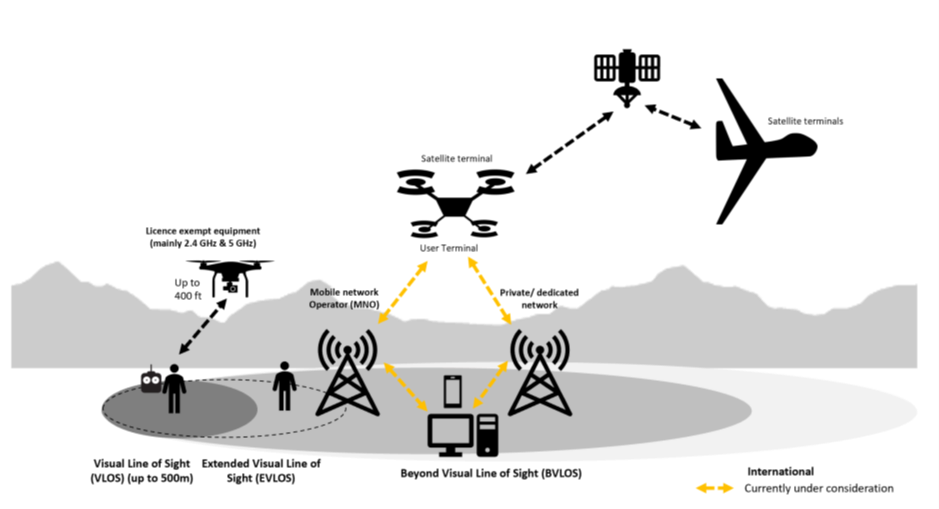
Source: OFCOM, June 2022
Relaying of payload data – for data and video to be sent from the UAS to the remote pilot/operator;
Electronic Conspicuity – technology to make other airspace users aware of the UAS’s location and flight path;
Detect and Avoid – the capability for the UAS to avoid objects or other aircraft to a level at least equivalent to the ‘see and avoid’ principle in crewed aviation; and
Communications, navigation, and surveillance – depending on the airspace in which the UAS is being flown and also on the capability of other systems on the UAS, Air Traffic Controllers may need to maintain oversight and control of the flight.
What kind of radio link is, or will be, used between the drone and the ground?
- Today for most drones: direct radio link, like a model aircraft
- Now and for drone operations with a range in kms: 4G 5G mobile and satellite networks
As a result, as the operational range of UAS flights is increasing, a radio link or Wi-Fi link is not suitable and does not provide the necessary coverage.
Cover all drones a company or individual operates in the UK and territorial waters but does not cover international flights.
Have an indefinite duration, subject to payment of an annual licence fee of £75.
Authorise a range of specific radio equipment that may be needed for future drone operations, including beacons and safety equipment that may be mandated by the CAA. The list of equipment will be kept under review and, subject to consultation, will be updated to reflect changes in technology or the overarching air safety framework.
Permit the use of satellite and mobile technologies while requiring the specific agreement of the network operator(s).No transmission will be permitted in the 2.6 GHz band.
This licence does not replace the current licence exemption regime for low power 2.4 GHz and 5 GHz equipment which most drones on the market currently fall under. “
Source: OFCOM “ Spectrum for Unmanned Aircraft Systems (UAS): Approach to authorising the use of radio equipment on UAS”, December 2022.
What is the impact in terms of security?
- 4 G/5G mobile networks and satellite networks are used in a broad array of end-user industries, including mobile online banking. Of course, both types of networks are prime targets for cybercriminals. However, industries have developed cybersecurity strategies and standards to securely support a large array of multi-billion or trillion client industries, and drone connectivity will benefit from that umbrella.
Still, what happens if a drone loses its C2 link?
Redundancy of communication links
Fail-safe modes automatically triggered by the loss of C2 signal, without the need for human input. Typically, drones on the market would perform one of three things: return to home (RTH), hover on the spot, or land, or a combination of those.
“Return to Home” RTH is the most typical solution used in the industry and simply means that if the C2 link is lost and can’t be recovered, the drone will automatically reverse (whether this is straight away or after a set amount of time) and go back to the home point where the flight started, or to a pre-determined safe landing point. This will also activate when the battery charge is running low.
Paired with the RTH function are the landing protection mechanisms. The drone has sensors and gyros onboard so that it will first hover then find a safe area to land without risking contact with uneven terrain or other objects e.g., rocky terrain or forested areas – or people of course.
Anti-jamming equipment onboard.
For more information, check the documents shared in the library.
Most drones on the market today are operated within close distance of the Remote Pilot, using a direct radio link like model aircrafts for Control and Command. These radio links are vulnerable to interferences, starting with unintentional interferences (terrain, buildings…) and drones have procedures in case of loss of communications link. For longer distance drone operations in kilometres like those considered as part of Project CAELUS, the most appropriate communication links are 4G 5G mobile networks and satellite communications networks. These networks have developed cybersecurity strategies and standards to support multi-billion end-user industries, and drone connectivity will benefit from it. In the UK, OFCOM, the communication regulator, issued in December 2022 its decision to set up a mobile and satellite communications onboard equipment licence for UAS.
Logistics by drone will be a form of transport like any other form of transport. In our discussion, we will share our understanding of regulations and best practices that would apply to the transport of medicines and medical products. We focus in particular on Good Distribution Practices, and the safe transport of dangerous goods by air. Richard walks us through the packaging solutions to meet those requirements.